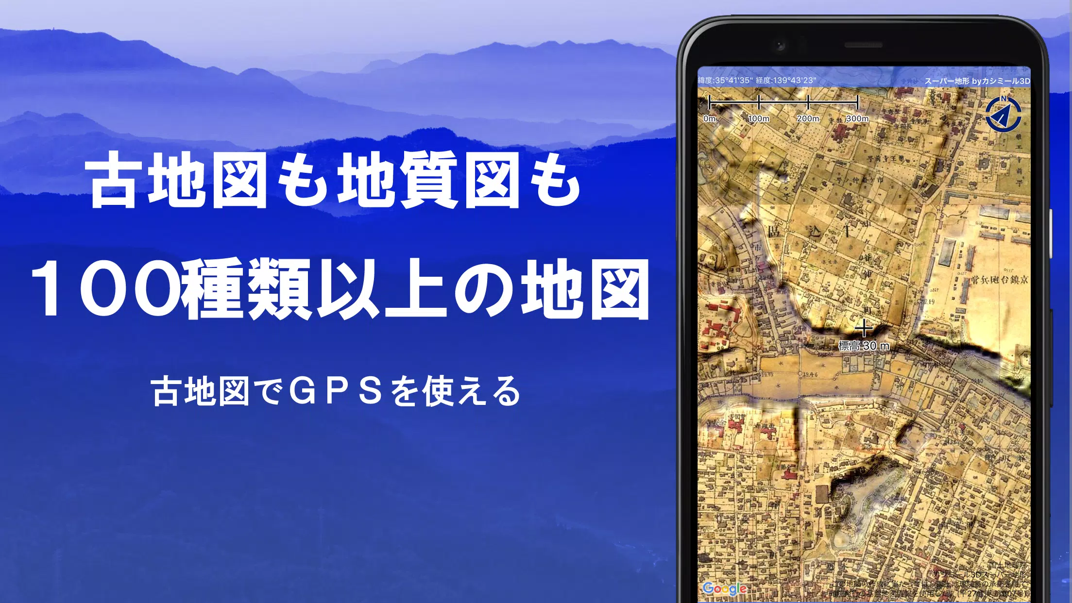
Discover over 100 types of maps at your fingertips, including the renowned Geographical Survey Institute map, which can elevate your experience from mountain climbing to urban strolls. This versatile app, honored with the 2018 Japan Cartographic Society Award for Best Work, utilizes "super terrain data" to provide an immersive terrain experience through its unique technology.
Users can leverage a vast array of maps from the Geospatial Information Authority of Japan, including topographic maps, geological maps, old maps, historical maps, and prewar topographic maps from the Ordnance Survey Department. The app's GPS function allows you to record tracks (trajectories) and supports GPX log input/output and editing functions, enhancing your outdoor adventures.
Equipped with features to aid in walking around town, mountain climbing, and other outdoor activities, the app offers GPS navigation with audio, data recording, and editing capabilities. A visibility determination function is available for creating cross-sectional diagrams, aiding in observation and radio communication, and can display buildings. The app also boasts a 360° panoramic view function for mountain identification and displaying the sun, moon, and GPS points.
For those venturing into areas without radio signals, the app's GPS function, bulk map download, and map cache features ensure a smooth offline experience. You can associate photos with points, display contour lines generated from elevation data, showcase MGRS grids (UTM grids), and handle GIS data from GeoJSON files. Additionally, you can draw shapes, use the app overseas, print maps, generate PDF outputs, and enjoy a dark theme for a better viewing experience.
A Wealth of Maps for Every Need
Explore over 100 map types, including combinations of our own super topographic data, maps from the Geospatial Information Authority of Japan, and hazard maps. Note that aerial photographs may vary in availability by age group, with "Latest" and "around 1974" offering wider coverage. Enjoy a 5-day free trial of maps using super terrain data upon installing the app.
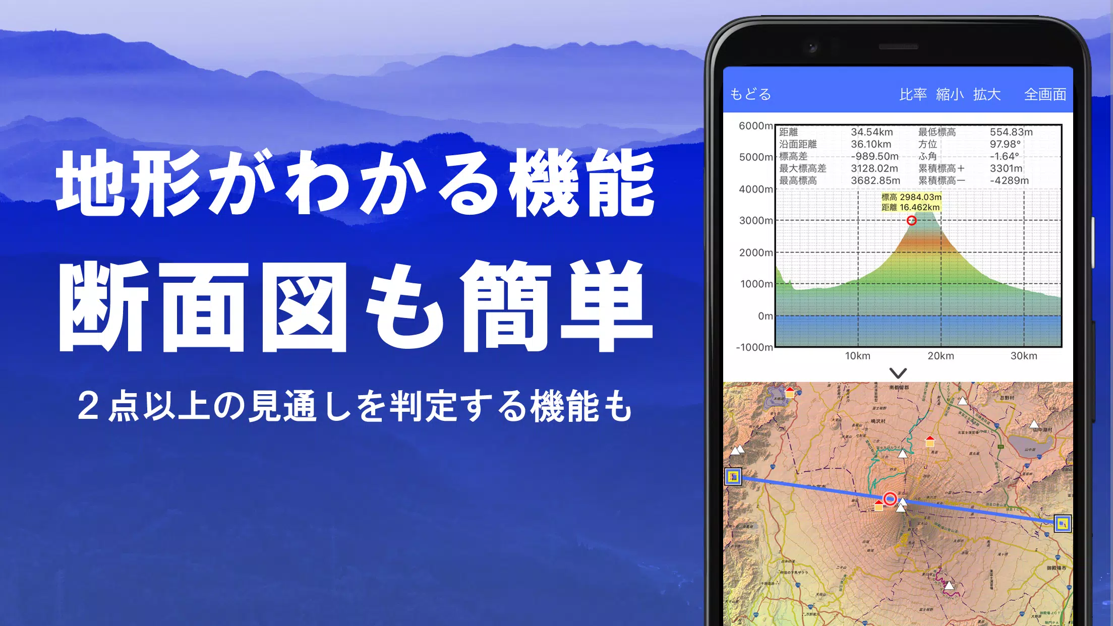
Cross Sections and Outlooks
Effortlessly create cross-sectional views through any point on the map. The app features a familiar visibility judgment function from Kashmir 3D, accounting for Earth's curvature and atmospheric differences. This is invaluable for route planning during climbs, assessing wireless visibility, and understanding the terrain. Where PLATEAU building data exists, you can include buildings in your cross-sectional views.
Elevation Palette Function
With the elevation palette function, you can customize the map's background color in 1cm increments, enhancing your visual experience with your preferred color gradients.
Panoramic View
Enjoy a panoramic observation map that displays mountain names from any location. This 360° panorama links with your smartphone's compass for accurate mountain identification. You can also view the sun and moon, including moon phases, which is perfect for spotting Diamond Fuji and Pearl Fuji. The app supports displaying GPS points and panoramic views of mountains abroad.
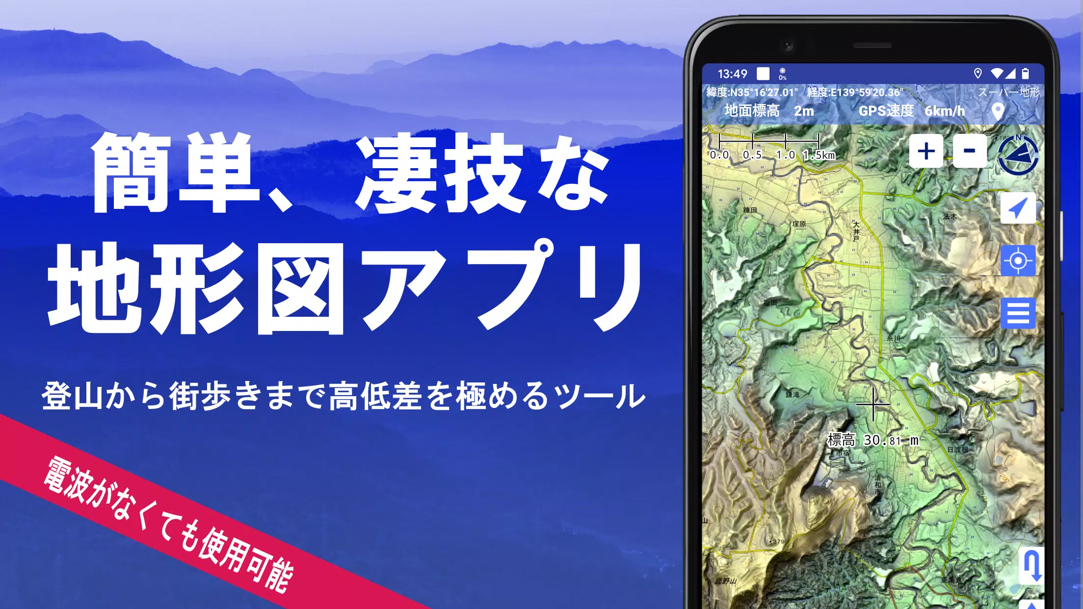
GPS Function
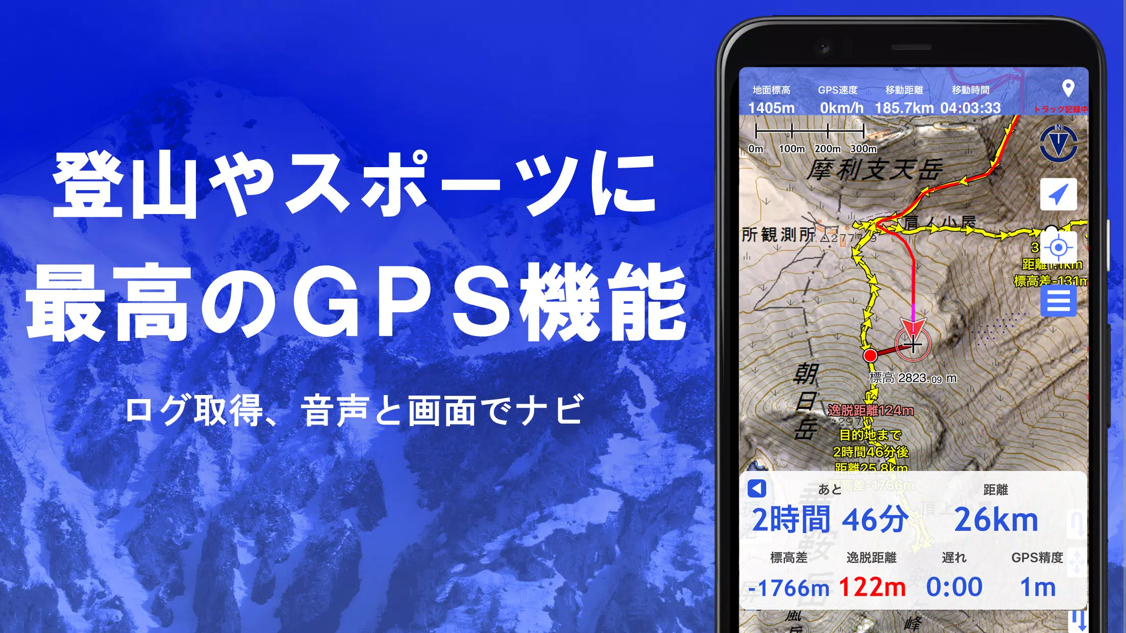
Leverage your smartphone's GPS to obtain location information and record tracks. The app features high-precision positioning suitable for serious mountain climbing and outdoor activities. Visualize your recorded tracks with parameters like elevation, speed, time, and elapsed time. A point alarm function alerts you with voice and sound as you approach designated points. Display photos associated with specific points and send the map center position to NaviCon.
GPS Track Summary Playback
The track playback function lets you review your tracks comprehensively. It matches and automatically displays photos based on their timestamps, showing icons at photo locations that you can tap to view.
GPS Navigation Function
Navigate using preset tracks with the Track Navi feature, which alerts you with voice or alarm if you deviate from the route, ensuring you stay on course during climbs. The app also supports route navigation for urban walks and point navigation to reach specific locations.
GPS Data Editing Function
Manage GPS-related point, route, and track data, organizing them in folders with a user-friendly tree format. You can create tracks directly on the map and import/export data in GPX format from various mountain climbing sites.
Map Usage Outside the Service Area (Offline)
Utilize maps even in areas without signals, thanks to the bulk download feature that ensures you have all necessary scale maps for the specified area. The cache function further enhances your offline experience, and a map history function lets you return to previously viewed locations.
Custom Map Compatibility
Import and use custom maps created with Kashmir 3D's map cutter, displaying your own maps and scanned images. When using the map cutter, divide images into approximately 256 x 256 segments and send the kmz file to Super Terrain via email or Cloud Drive.
GeoJSON Compatibility
Display and edit points, linestrings, and polygons from GeoJSON format files, allowing you to draw new shapes.
Print/PDF Output
Print any map area at a specified scale or create a PDF for later use.
Cooperation with Other Apps
Exchange GPS data in GPX, KML, and GDB formats with other apps, the PC software "Kashmir 3D," and trajectory data from mountain climbing sites.
Backup Function
Backup all app data (excluding cached maps) and store it off your smartphone. Restore data even if you delete the app or face device issues. An automatic backup feature using Google Drive keeps your data up-to-date. Refer to the manual for more details.
About Billing Function
Some features, such as maps using super terrain data, GPS track functions, and cross-sectional views, require in-app purchases. After payment, the number of search results for place name searches will increase.
●Fees: Annual payment of 780 yen/year.
●Free Trial: Enjoy a 5-day free trial upon first installation. After 5 days, some features and maps may become unavailable. No charges will be made unless you opt for a purchase within the app under [Settings] - [Purchase to remove functional restrictions].
●Confirmation and Cancellation: Check or cancel automatic updates via Google Play by navigating to "Regular Purchase" and selecting "Super Terrain."
●Price Revision: Future feature enhancements may lead to price revisions. Early purchase is advantageous.
Terms of Use
The copyright holder and developer are not responsible for the outcomes of using this application. Upon first use of GPS, you'll be prompted to allow location services. Continuous GPS use can drain the battery, so carry a spare battery if your device is used for emergency communication. For a detailed explanation of the navigation function, refer to the PDF at https://www.kashmir3d.com/online/superdemapp/superdem_navi.pdf. Note that some smartphones may interrupt or fail to record tracks due to power-saving features closing background apps; temporarily turning off the screen can help, but this isn't a permanent solution.